Hikers Peril
Tamassee

Hikers Peril

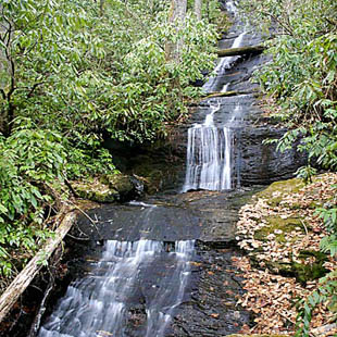
Hikers Peril is also known to locals as "HemlockFalls" most likely becasue of the many Hemlock trees surrounding the falls. Hikers Peril is also crossed by The Foothills Trail a few feet downstream.

DIRECTIONS:

1.  From Walhalla drive WEST on SC 28 for 8.1 miles then bear RIGHT (north) onto SC 107.

2.  Drive approximately 14.1 miles and park on your LEFT at an unmarked picnic area.

3.  Continue walking to The Foothills Trail (LEFT) and walk 0.5 miles and you will reach Hikers Peril. (On the way you will hear Sloan Bridge Falls on your right)


As we just provide information, if you have a question regarding a particular trail, it is best to contact the source listed. We encourage good stewardship of our natural resources.  Be prepared for your outing and Leave No Trace of your visit. For more hiking and waterfall trips, check out the publications of Milestone Press.

 
Disclaimer
The information on this website is used entirely at the reader's discretion, and is made available on the expressed condition that no liability, expressed or implied, is accepted by Discover Upcountry Carolina Association or any of its associates, employees or affiliates for the accuracy, content or use thereof. Links to other websites from this website do not imply endorsement by Discover Upcountry Carolina Association.


Discover More Waterfalls

Stay in touch!

Sign up to get a monthly UpcountrySC newsletter sent to your Inbox.


By submitting this form, you are consenting to receive marketing emails from: Upcountry South Carolina, 500 E. North Street, Suite C, Greenville, SC, 29601, https://www.upcountrysc.com. You can revoke your consent to receive emails at any time by using the SafeUnsubscribe® link, found at the bottom of every email. Emails are serviced by Constant Contact