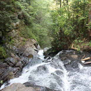
Blue Hole Falls
Mountain Rest, SC 29664
GPS Waypoints Lat: 34.7616 Lon: -83.1897
DIRECTIONS:
1. From Walhalla drive WEST on SC 28 for 6.6 miles and turn LEFT onto Whetstone Road (Oconee County S-37-193) just before the Mountain Top Trading Post.
2. Drive approximately 0.8 mile and turn LEFT onto Cassidy Bridge Road (Oconee County S-37-290).
3. Drive 0.9 mile and turn LEFT onto Rich Mountain Road (FS 744, gravel road).
4. Drive 3.3 miles and turn RIGHT onto Cedar Creek Road (FS 744C).
5. Drive 2.5 miles to FS 2658 (right side of the road) and PARK by an earth mound, which partially blocks access to FS 2658.
6. Hike 0.3 mile down FS 2658 to a “T” intersection and turn RIGHT.
7. Hike 0.2 mile to a short steep path on your LEFT that leads down to the creek (100 feet before the road ends. Take the 2nd trail. The 1st ends at an overlook of the Falls.).
8. Cross the creek at the base of Cedar Creek Falls and follow the faint path downstream to the waterfall.
9. This poorly defined path becomes more evident as it skirts the right side of the pool at the base of the waterfall.