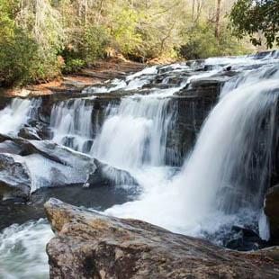
Big Bend Falls gets its name from the hairpin turn in the Chattooga River just above the falls. You'll find a 30 foot drop which includes a 15 foot block waterfall, the highest single drop on this Wild and Scenic River. Below the falls are small sandy beaches and large boulders to relax and picnic. The hike takes you through a forest of mountain laurel, white pines and hemlocks. Expect a two hour hike (one way) along this 3.4 mile trail.
GPS Waypoints Lat: 34.9533 Lon: -83.1193
DIRECTIONS:
1. From Walhalla, drive NORTHWEST on SC 28 for approximately 8 miles and bear RIGHT (north) onto SC 107.
2. Drive 10.4 miles and turn LEFT (west) onto Burrells Ford Road (FS 708, which is paved for first 0.3 mile).
3. Drive approximately 3 miles to the parking area on the left.
4. From the southern end of the parking area, hike on the Chattooga Trail (black blazes) and the Foothills Trail (white blazes), which run concurrently along this stretch of the river.
5. At 2.5 miles the Big Bend Trail intersects the other two from the east. Approximately, 0.5 mile beyond this intersection, you will hear the roar of the falls. Use one of the several rugged paths that drop along the laurel covered banks to access the falls. The banks are steep and slippery. Use extreme caution.
As we just provide information, if you have a question regarding a particular trail, it is best to contact the source listed. We encourage good stewardship of our natural resources. Be prepared for your outing and Leave No Trace of your visit. For more hiking and waterfall trips, check out the publications of Milestone Press.
Disclaimer
The information on this website is used entirely at the reader's discretion, and is made available on the expressed condition that no liability, expressed or implied, is accepted by Discover Upcountry Carolina Association or any of its associates, employees or affiliates for the accuracy, content or use thereof. Links to other websites from this website do not imply endorsement by Discover Upcountry Carolina Association.
Discover More Waterfalls