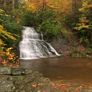
This popular waterfall, also known as Wildcat Wayside Falls, can be viewed by everyone as it located roadside on Highway 11. This 30-foot waterfall is last in a series of three formed by the Wildcat stream. About 100 feet to the left of the falls are steps that lead to the 10-foot middle falls and the 100-foot upper falls. NOTE: the State Park Service has closed the trail to the upper falls because of the many previous accidents. But an excellent view of the upper falls is possible without crossing the dangerous boulders.
GPS Waypoints Lat: 35.0748 Lon: -82.5968
DIRECTIONS:
1. NORTH from Greenville to US 276
2. On the RIGHT after US 276/ Hwy. 11 junction, about 5 miles
3. Park in the large paved roadside area, 0.6 miles before US 276 makes a right turn toward Caesar's Head State Park
As we just provide information, if you have a question regarding a particular trail, it is best to contact the source listed. We encourage good stewardship of our natural resources. Be prepared for your outing and Leave No Trace of your visit. For more hiking and waterfall trips, check out the publications of Milestone Press.
Disclaimer
The information on this website is used entirely at the reader's discretion, and is made available on the expressed condition that no liability, expressed or implied, is accepted by Discover Upcountry Carolina Association or any of its associates, employees or affiliates for the accuracy, content or use thereof. Links to other websites from this website do not imply endorsement by Discover Upcountry Carolina Association.

