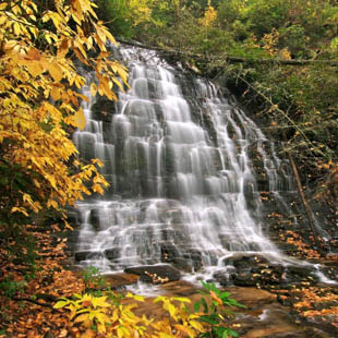
Spoonauger Falls
Mountain Rest, SC 29664
This 50-foot falls, also known as Rock Cliff Falls, is set back into a hillside and surrounded by heavy vegetation as it rushes over a stepped rock face in a broad sheet. Fed by Spoonauger Creek, the falls is named for the Spoonauger family who lived at the top of the falls. This is one of the more popular waterfalls in this area because of the easy 20-minute hike and its camera-friendly appearance. During daylight hours, tiny bats tuck themselves into crevices in the rock face of the falls.
GPS Waypoints Lat: 34.9746 Lon: -83.1097
DIRECTIONS:
1. From Walhalla, drive NORTH on SC 28 for 8 miles to the junction of SC 28 and SC 107, and bear RIGHT (north) onto SC 107.
2. Drive 10.4 miles and turn LEFT onto Burrell's Ford Road (FS 708, paved for first 0.3 mile).
3. Drive approximately 2.5 miles to the Chattooga Trail parking area on the LEFT (look for the Forest Service Bulletin Board).
NOTE: There may not be a sign for the Chattooga Trail.
4. Hike NORTH on the Chattooga Trail, which roughly parallels the Chattooga River for 0.25 mile, then CROSS Spoonauger Creek.
5. Immediately turn RIGHT at the sign for Spoonauger Falls. Continue upstream for 200 yards to reach the falls.
